
Report On the State
of the Environment In China
2 0 0 3
The Climate and Natural Disasters
![]() General Situation:
General Situation:
General Climate Situation of the Country: In 2003 (between December 2002 and November 2003), the average annual precipitation of the country was more than historical average, but the distribution of precipitation was uneven. Precipitation was significantly more than historical average in the north. It was the second most rainy year for the north since 1961. Precipitation was less than historical average in the south. 2003 was the least rainy year for the south of China since 1961. Serious floods happened in the Huaihe River Basin in the flood season and in the middle and lower reaches of the Yellow River in autumn. Large-scale drought happened in the northeast in spring and in the south in summer and autumn. The average temperature of the year was slightly higher than the historical average, and it had been the seventh consecutive year for the average temperature of the year to be higher than the historical average. 2003 was the fifth warmest year since 1961. China's southeast and south were attacked by rare hot weathers in summer.
In 2003, there were frequent climactic disasters. Typhoons and sandstorm disasters were less serious than the previous several years; but droughts, storms, floods, heat, unbroken spell of rainy weather, and hails were more serious. The climactic disasters of 2003 were "slightly more severe than medium level".
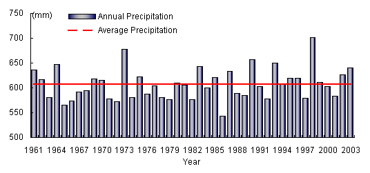
Changes of Annual Precipitation in China (in millimeters)

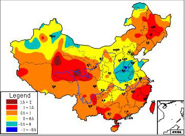
Distribution of Precipitation in 2003 in Terms of
How Many Percent It is More Than the National Average (%)
The Distribution of Precipitation: In 2003, the average precipitation of the country was 640.9 mm, which was 33.9 mm more than historical average. In the northern regions, the average precipitation was significantly more than the previous four consecutive dry years. It was the 2nd most rainy years since 1961. In the south, precipitation was less than the historical average. It was the least rainy years for the southeast and the south since 1961. In most areas to the south of Wei River and the Yellow River, and in the eastern and the southern parts of China's southwest, precipitation was generally between 800-1500 mm. In certain areas of these regions, precipitation was more than 1500 mm. In the most parts of China's northeast and the north as well as the southeastern part of China's northwest, precipitation was between 300- 800 mm. In the central and western parts of China's northwest, precipitation was less than 300 mm. In the most parts to the north of the Yangtze River, and in the northern parts of China's northeast, precipitation was more than historical average. In particular, in the western parts of the Yellow River Basin and the Huaihe River Basin, and in the southern parts of Xinjiang, precipitation was 50-100% more than the historical average. In the areas to the south of the Yangtze River, and in the eastern and central southern parts of China's northeast, precipitation was less than the historical average.
The Distribution of Temperature: The national average temperature in 2003 was 9.9 degrees centigrade, which was 0.6 degrees centigrade higher than the historical average. It was the 7th consecutive years for the average temperature to be higher than the historical average. The temperature in the south was significantly higher than the historical average, and it was the warmest year since 1961. With the exception of the southern parts of North China and the western parts of the Yellow River Basin and the Huaihe River Basin, the average temperature was higher than the historical average in most parts of China. In particular, the temperature of the central parts of the northeast, the southern parts of the northwest, and some parts of the south was 1-2 degrees centigrade higher than the historical average.
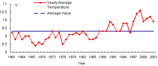
Changes of Yearly Average Temperatures in China (°C)
Distribution of Temperature in 2003 in Terms of
How Many Percent It Is More than the National Average (°C)
Climactic Disasters: In 2003, China experienced various kinds of climactic disasters and abnormal weathers, such as droughts, storms, floods, high temperature, unbroken spells of rainy weather and low temperature, typhoons, hails, sandstorms, snow disasters, cold disasters, and heavy fogs, etc. The climatic disasters were "slightly more serious than medium level". The main climactic disasters were droughts, rainstorms, and floods. The area affected by these disasters accounted for three fourths of the total area affected by all climactic disasters.
[Droughts:] The main characteristics of the droughts in 2003 were that the northeast had droughts in spring, whereas the south had droughts in both summer and autumn. In most parts of the northeast, precipitation had been very little since the autumn of 2002, and was 30-80% less than the historical average during winter and spring. In particular, the average precipitation of the northeast from January to May was the least since 1954, just after1993 and 1965. At the height of summer, most parts to the south of the Yangtze River had high temperature and little precipitation. From July to the first ten days of August, precipitation was only 50-200 mm, which was 30-80% less than historical average. In autumn, precipitation in most parts of the south was less than historical average. In particular, Zhejiang, Guangxi, Hunan, Fujian, and Guangxi had suffered from continuous droughts since summer. The average precipitation between July and November in these five provinces was far less than the historical average, and was the least since 1954.
[Rainstorms and Floods:] In the rainy season (June 21 – July 22), the Huaihe River Basin had 6 concentrated raining processes, which brought 400-500 mm of precipitation to most areas. In the areas along the Huaihe River in Jiangsu and Anhui, and in parts of southeastern Henan, the precipitation was 500-600 mm, being1-2 times the level of the historical average. During the main flood period, the average precipitation of the Huaihe River Basin ranked the 2nd (only after 1954) of the previous 50 years. Due to the concentration of raining areas and raining period as well as the large volume of precipitation, the water levels of the mainstream and branches of Huaihe River were raised high and exceeded the warning levels. The sluice gate of Wangjiaba Dam was opened twice on July 3 and July 11 respectively in order to lower the water level. Huaihe River had the biggest flood since 1991.
[High Temperature:] In the summer of 2003, South China was hit by large-scale heat waves. In particular, high-temperature weather persisted for over a month in the southeast and the south. It persisted for nearly two months in certain areas. This was rare in recent history. The highest summer temperature was 38-40 degrees centigrade in the middle and lower reaches of the Yangtze River and the northern parts of South China, and was as high as 40-43 degrees centigrade in central and southern Zhejiang, northern Fujian, and central Jiangxi. The highest temperature in Zhejiang, Fujian, most of Jiangxi, and certain parts of Jiangsu, Anhui, Guangdong, and Guangxi exceeded the historical record of the same period. The number of high-temperature days was 10-30 in the middle and lower reaches of Yangtze River and the regions to the south of the Yangtze River, and was 30-50 in the central and eastern parts of the south, and the northern part of the southeast. Compared with the same period of previous years, both the number of days with temperature of higher than 35 degrees centigrade at the height of summer (from July to the first ten days of August) and the number of days with temperature of higher than 38degrees centigrade during summer (from June to August) were the most since 1961.
[Typhoons:] In 2003 (from January to December), 21 typhoons were formed in the northwest Pacific and the South China Sea. Among them, 6 landed in China. The number of typhoons landed in China was fewer than historical average, and the economic loss caused was also less. However, the No. 7, 12 and 13 typhoons were very strong and destructive, and caused great damage to some coastal regions.
[Sand Storms:] In the spring of 2003, seven sand and dust weather processes happened in China. Among them, two were sand storms. Compared with previous years, the number and scale of the sand and dust weather processes were less, and therefore their effect was less serious.
[Snow Disasters:] In the winter of 2003 (December 2002 to February 2003), due to the effect of frequent cold air, Inner Mongolia had one of the rarest large-scale snow and drastic temperature drop in the past 30 years. The duration of the snow was long, and snow storms happened in certain areas such as the grazing areas of Xilin Gol League and Hulunbuir. Take the grazing areas of Xilin Gol League as an example. Snow had been accumulated in most areas in late October of 2002, and in certain areas, there had already been snow disasters. In the second half of December 2002, continuous snow fell, accompanied with drastic temperature drop, which made the snow disasters more extensive. In the worst case, the snow was 20-40 cm deep. In January 2003, the snow disaster became worse. By the end of February, animals were still unable to go out for food.
Earthquake Disasters: In 2003, China had 37 earthquakes of greater than degree 5, among which 1 was greater than degree 7, 7 were degree 6-7, and 29 were degree 5-6. 27 earthquakes occurred in the mainland, 7 occurred in Taiwan, 2 occurred in the East China Sea, and 1 occurred in the South China Sea.
21 of the earthquakes that occurred in the mainland caused disasters. The total area affected by the disasters was approximately 78,143 km2. The population affected by the disasters was 2.98 million. 319 people died. The direct economic loss caused by earthquake disasters was RMB 4.66 billion.
Geological Disasters: In 2003, 13,832 geological disasters occurred in China, causing 743 deaths, 125 people missing, 564 people wounded, and a direct economic loss of RMB 4.865 billion. Geological disasters were relatively more serious in Sichuan, Shannxi, and Hunan.
Marine Disasters: 2003 was an average year in terms of marine disasters. The direct economic loss caused by marine disasters was RMB 8.05 billion, which was about 22% more than the previous year. The population affected by the marine disasters was over 20 million, among which there were 128 deaths and missing people. The wind and storm waves caused RMB 7.877 billion worth of direct economic loss, and 25 deaths and missing people, and were the main marine disasters in 2003.
Typhoons That Landed in China in 2003
| No. (Name) | Date Landed | Venue Landed | Biggest Wind Force (Degree) | Affected Areas |
Summary of Damage |
| 0307 Imbudo |
July 24 | Yangxi - Dianbai of Guangdong | 12 | Guangdong, Guangxi, Hainan | 520,000 hectares of affected area; 28 deaths; 29,000 rooms destroyed; RMB 3.3 billion of direct economic loss |
| 0308 Swan |
July 21 | Wanning of Hainan | 9 | Hainan | 25,000 hectares of affected area; 1,900 rooms destroyed; RMB 190 million of direct economic loss |
| 0309 Morakot |
August 3 | Taidong of Taiwan | 10 | Fujian, Guangdong | 14,000 hectares of affected area; 5 deaths; 9,800 rooms destroyed; RMB 240 million of direct economic loss |
| August 4 | Jinjiang of Fujian | 8 | |||
| 0311 Vamco |
August 20 | Pingyang of Zhejiang | 9 | Zhejiang | 7,000 hectares of affected area; 1,000 rooms destroyed; RMB 70 million of direct economic loss |
| 0312 Krovanh |
August 25 | Wenchang of Hainan; Xuwen of Guangdong | 12 | Hainan, Guangdong, Guangxi | 396,000 hectares of affected area; 3 deaths; 19,000 rooms destroyed; RMB 3.18 billion of direct economic loss |
| 0313 Cuckoo |
September 2 | Huidong; Shenzhen; Zhongshan of Guangdong |
12 | Guangdong | 260,000 hectares of affected area; 44 deaths; 7,800 rooms destroyed; RMB 2.49 billion of direct economic loss |
Major Sand and Dust Weathers in China in the Spring of 2003
| No. | Start and End Date | Type | Main Weather Systems |
Main Areas affected |
Wind Force (Level) |
| 1 | Apr 8-11 | Sand Storm | Cold air; low air pressure | Raised sand happened in Nanjiang Basin, most parts of Qinghai, the central parts of Gansu, the central parts of northern Inner Mongolia, northern Ningxia, northern Shanxi, and southwestern Shanxi. Sandstorm happened in Kuche, Luntai, Andehe, and Awati of Xinjiang; northwestern and southern Qinghai; some areas in central Gansu; some areas in central and western Inner Mongolia; and Yanchi of Ningxia. In particular, heavy sandstorm happened in Jinta of Gansu; Mangya, Maduo, Maqin, Dari, and Gande of Qinghai. | 5-6; 7 in some areas |
| 2 | Apr 13-15 | Raised Sand | Mongolian cyclone; cold air | Raised sand happened in northwestern Gansu, northwestern Inner Mongolia, parts of central and eastern Inner Mongolia, and western Liaoning. Sand storm happened in western Inner Mongolia and parts of central Inner Mongolia. | 5-7 |
| 3 | Apr 15-17 | Raise Sand | Mongolian cyclone; cold air | Raised sand happened in southern Xinjiang, northwestern Qinghai, western Gansu, western Inner Mongolia, western Liaoning, western Jilin, and southwestern Heilongjiang. Sandstorm or heavy sandstorm happened in parts of southern Xinjiang, northwestern Qinghai, western Gansu, western Inner Mongolia, and western Jilin. | 5-6 |
| 4 | Apr 20-21 | Sand Storm | Cold air | Raised sand happened in northern Qinghai, central and western Gansu, central and western Inner Mongolia. Sand storm happened in Lenghu of Qinghai and Yumen Town of Gansu. | |
| 5 | May 1-2 | Raised Sand; | Cold air; Mongolian cyclone | Raised sand happened in central Heilongjiang, Jilin, and western Liaoning. Sand storm happened in parts of Jilin and western Liaoning. | |
| 6 | May 2-5; | Raised Sand Cold air | Mongolian cyclone | Raised sand happened in southern Xinjiang, central Gansu, and western Inner Mongolia. Sand storm or heavy sand storm happened in parts of southern Xinjiang and western Inner Mongolia. | |
| 7 | May 7 | Raised Sand | Cold air | Raised sand happened in parts of western Liaoning. | 5-6; 7 in some areas |
Earthquake Disasters and Their Damage in the Mainland of China in 2003
| No. | Date | Venue | Earth -quake Level |
Casualties (Persons) | Damage to Buildings (m2) | Direct Economic Loss (RMB 10,000) |
||||||
| Day /Month |
Time | Deaths | Seriously Wounded | Lightly Wounded | Destroyed | Serious | Medium | Light | ||||
| 1 | 04/01 | 19:07 | Jiashi, Xinjiang |
5.4 | 14135 | 48115 | 150770 | 295829 | 3120 | |||
| 2 | 14/02 | 1:34 | Shihezi, Xinjiang |
5.4 | 50 | |||||||
| 3 | 24/02 | 10:03 | Bachu-Jiashi, Xinjiang |
6.8 | 268 | 2058 | 2795 | 2452193 | 2119473 | 2277530 | 2872992 | 139792 |
| 4 | 17/04 | 8:48 | Delingha, Qinghai |
6.6 | 36389 | 67091 | 72593 | 67046 | 7324 | |||
| 5 | 24/04 | 6:37 | Shiquan, Shannxi |
4.5 | 1 | 2540 | 8710 | 388625 | 1302 | |||
| 6 | 04/05 | 23:44 | Jiashi-Yupuhu, Xinjiang |
5.8 | 1 | 3 | 157939 | 302770 | 387719 | 415684 | 7720 | |
| 7 | 17/06 | 22:46 | Xichang, Sichuan |
4.8 | 90 | 2460 | 179 | |||||
| 8 | 10/07 | 9:54 | Xichang-Zhaojue, Sichuan | 4.8 | 1 | 18710 | 66960 | 561 | ||||
| 9 | 21/07 | 23:16 | Dayao, Yunnan |
6.2 | 16 | 110 | 683 | 48410 | 505274 | 2100520 | 5211078 | 59190 |
| 10 | 16/08 | 18:58 | Balinzuoqi- Aluke'erqinqi, Inner Mongolia |
5.9 | 4 | 60 | 1004 | 12190 | 26115 | 33975 | 36395 | 80649 |
| 11 | 18/08 | 17:03 | Bominan, Tibet |
5.7 | 2 | 4 | 10 | 4342 | ||||
| 12 | 21/08 | 10:16 | Yanyuan, Sichuan |
5.0 | 2 | 7 | 14200 | 70160 | 113465 | 2187 | ||
| 13 | 02/09 | 7:16 | Aketao, Xinjiang |
5.9 | 847 | |||||||
| 14 | 27/09 | 19:33 | China-Russia Border |
7.9 | 10722 | 99135 | 198551 | 498827 | 7636 | |||
| 15 | 16/10 | 18:28 | Dayao, Yunnan |
6.1 | 3 | 15 | 42 | 44369 | 198273 | 1088551 | 3516024 | 41560 |
| 16 | 25/10 | 20:41 20:48 |
Minle-Shandan, Gansu |
6.1 5.8 |
10 | 14 | 32 | 376070 | 844981 | 947038 | 1285368 | 50140 |
| 2235 | 59694 | 78836 | 94423 | 4078(1) | ||||||||
| 17 | 13/11 | 10:35 | Minxian-Lintan, Gansu |
5.2 | 1 | 17 | 116 | 46242 | 219916 | 414211 | 548266 | 8792 |
| 18 | 15/11 | 2:49 | Luxun, Yunnan |
5.1 | 4 | 24 | 70 | 19960 | 118716 | 423560 | 2592635 | 19190 |
| 19 | 25/11 | 13:40 | Hongdong, Shanxi |
4.9 | 4 | 7 | 200 | 60 | 80 | 1100 | 55 | |
| 20 | 26/11 | 21:38 | Luxun, Yunnan |
5.0 | 2 | 22 | 15010 | 88641 | 1264626 | 141190 | 9300 | |
| 21 | 01/12 | 9:38 | China-Kazakhstan Border | 6.1 | 10 | 21 | 23 | 48983 | 121882 | 528009 | 934600 | 18026 |
| Total | 319 | 2332 | 4815 | 3285047 | 4836876 | 10064239 | 19082967 | 466041 | ||||
Note (1): The casualties, damage to buildings, and direct economic loss in the row refer to the loss caused by the 6.1 earthquake in Inner Mongolia.
Loss Caused by Major Marine Disasters in 2003
| Type of Disasters | Times of Occurrence | Times of Disasters | Deaths and Missing People | Direct Economic Loss (RMB 10 million ) |
| Windstorm Tides | 14 | 5 | 25 | 78.77 |
| Red Tides | 119 | 14 | 0 | 0.43 |
| Billow Disasters | 34 | 10 | 103 | 1.15 |
| Oil Leakages | 5 | 2 | 0 | 0.17 |
| Total | - | - | 128 | 80.52 |
Note: The loss caused by offshore waves is included in "Windstorm Tide"
![]() Countermeasures and Actions:
Countermeasures and Actions:
Meteorological Pre-warning and Forecasting for Geological Disasters in the Flood Season: The State Meteorological Administration and the Ministry of Land Resources jointly conducted pre-warning and forecasting for geological disasters in the flood season. From June 1, pre-warming and forecasting information was publicized on the CCTV. Various provinces also conducted pre-warning and forecasting for geological disasters. They issued over 500 warnings or forecasts for landslides or sand & mud flows, and successfully avoided 697 geological disasters, 29,514 deaths, and RMB 400 million worth of economic loss.
Artificial Precipitation for the Prevention of Hailstorms: 30 provinces had artificial precipitations to prevent hailstorms. The area covered by artificial precipitation was 3 million km2, and hailstorm was prevented for 420,000 km2.
The Earthquake Monitoring System: By the end of 2003, an earthquake monitoring system consisting of three levels (national, regional, and county) had been basically established. This system included: a national digital earthquake station network consisting of 48 earthquake stations; a digital remote sensing earthquake station covering 23 provinces, a earth crust movement monitoring network consisting of 25 continuous monitoring stations for GPS baseline data, 56 monitoring base stations, and approximately 1,000 mobile monitoring stations. 159 digital pre-warning monitoring stations were upgraded or expanded. 50% of existing earthquake monitoring stations and 30% of existing pre-warning monitoring stations were digitized. All earthquakes of greater than 4.0 degrees could be monitored effectively. The National Fast Reporting Network for Major Earthquakes could report the timing, venue, and degree of an earthquake within 25 minutes of its occurrence. Regional remote monitoring network at provincial level could report an earthquake within 15 minutes of its occurrence.
Prevention of Earthquake Disasters: The national Zoning Map for Earthquake Indicators was compiled. It provided scientific and rational requirements for key engineering projects and general civil constructions to adopt precautions in order to prevent earthquake disasters. This signified a transition: Previously, engineering and construction projects had been required to be able to prevent disasters caused by certain degrees of earthquakes; now, the new requirements require them to meet certain standards for various earthquake indicators.
Earthquake Emergency Rescue: The State Council and the Central Military Committee of the CPC approved the establishment of China's first national Earthquake Emergency Rescue Team. This team carried out two domestic and two international rescues in response to the 6.8 degree earthquake in Bachu-Jiashi of Xinjiang in February 2003, the 6.7 degree earthquake in Albania in May 2003, the earthquake in Zhaosu of Xinjiang in December 2003, and the 7.0 degree earthquake in Bam of Iran in December 2003 respectively. These rescues demonstrated that China's earthquake emergency rescue team had been basically capable of accomplishing domestic and international rescue tasks.